


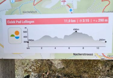
10,5 km | 15,3 km-effort

Plus vî, plus sot


Kostenlosegpshiking-Anwendung
 SityTrail
IGN / Geografische Institute
SityTrail World
Die Welt öffnet sich für Sie
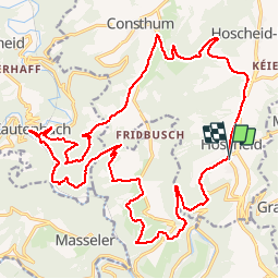
Tour Mountainbike von 26 km verfügbar auf Unbekannt, Kanton Clerf, Park Hosingen. Diese Tour wird von Yeyette VTT team vorgeschlagen.
Une côte infernale vers l'arrivée, mais superbe parcours


Wandern
Wandern
Wandern
Wandern
Wandern
Wandern
Wandern
Wandern
Zu Fuß